


you just might ALSO
enjoy ...

Whale explodes: Details at 11.
The highway department guy didn't know how much dynamite to use, and said so on camera. But he still thinks the operation was a success. Check out the story of Florence's famous exploding whale ...

Far-out guru "enlightens" Central Oregon.
What happens when a colony of acolytes of an East Indian guru move in, then try to take over Wasco County? Check out the four-part story of the rise and fall of Rajneeshpuram ...

this oregon youth went on to save half a billion lives...guess who?
A local Willamette Valley teen-ager named Bert Hoover, an orphan sent from Iowa to live with his uncle, went on to save millions of lives and become a singularly ill-starred U.S. president.
oregon's most spectacular shipwreck ever.
The steam schooner J. Marhoffer was almost brand-new when, burning fiercely from stem to stern, it piled onto the rocks near Depoe Bay. It's the remains of this fiery shipwreck that gave Boiler Bay its name ...
the gallant rescue of portland's floating brothel.
Maritime madam Nancy Boggs kept her bordello on a barge floating in the river, until a police raid cut it loose. But the captain and crew of a sternwheeler came to save the day. Here's the story.

take off to the province of oregon, eh?
Few people know how close Oregon came to officially becoming a British possession under the treaty that ended the War of 1812. Only the presence of a handful of scattered, starving survivors from Astor's fur enterprise prevented it. Here's how.

timberline lodge could have been a glass skyscraper
Calling the plan a "profit-making eyesore," a Forest Service manager nixed 1920s plan for a modern steel-and-glass structure with an aerial tramway. You can read about it right here.

pixieland: an edgy, vanished amusement park
Built in the late 1960s as a "fairy-tale history of Oregon," the amusement park lasted just a few years before slipping into receivership. Today, all that's left of this odd and uniquely Oregonian story is a dilapidated guardshack.

When the waters rise, Portlanders raise the sidewalks
In massive flood, Portlanders held boat races on downtown streets, caught steelhead in the train station lobby; a popular saloon moved onto a houseboat on Burnside
EDITOR'S NOTE: A revised, updated and expanded version of this story was published in 2017 and is recommended in preference to this older one. To read it, click here.
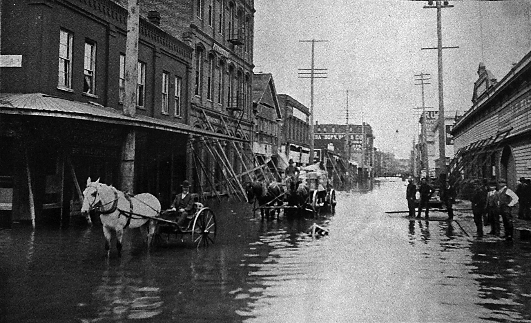
Wagon teams try to carry on with business on Front Street, just north
of the intersection with Taylor, during the 1894 flood. (Image: Portland
City Archives) [Larger image: 1831 x 1116 px.]
By Finn J. John — Sept. 16, 2009
Most Oregonians have at least heard of the 1996 flood. It was something to see, and for folks in places like Keizer and the Mohawk Valley north of Springfield, it was devastating.
Before that, many longtime Oregonians remember the Christmas flood that made history in '64. And really longtime Oregonians may remember the last one before that -- the 1948 monster that swept away the town of Vanport, on the Columbia north of Portland proper.
But those "modern" floods share an interesting characteristic ... they happened after flood-control dams had been built to tame this crazy Willamette River Valley. Places like Foster and Green Peter, Detroit Lake, Leaburg Lake, Dexter and Cottage Grove reservoirs -- they weren't built to give you a place to fish. They were built to keep your house from floating away.
Flood control plan: Just deal with it
Before the dams were in, the Willamette could be a rough neighbor. The very birthplace of the state — the town of Champoeg, at which citizens voted in 1843 to form a territorial government — washed away, all but one house, in 1861.

Nattily-dressed Portland businessmen carry on during the 1894 flood,
using a makeshift bridge to cross flooded Third Street at the intersection
with Washington Street. (Image: Portland City Archives) [Larger image:
1831 x 1103 px.]
Since then, the biggest flood on record has been the one that poured out over the river banks in 1894, and kept much of the Willamette Valley under water for weeks.
Down at the north end of the river, where it flows into the Columbia, the fast-growing town of Portland had learned to live with the seasonally rising water, with classic Oregon rough-and-ready style. When the river levels rose, storekeepers stacked piles of bricks on the plank sidewalks in front of their establishments to prevent them from floating away and built quick-and-dirty bridges to help pedestrians get from shop to shop without getting soaked (any more than usual, that is).
Floating saloon, boat races, steelhead fishing in Old Town
Even in the biggest flood, in 1894, no one seems to have considered closing for business until the floodwaters receded. A downtown Portland hotel built a temporary false floor in its lobby, so guests could keep their feet dry. The cook at the Bureau Saloon brought a rowboat into the kitchen and stood in it while he worked. The Meier & Frank department store built raised walkways for shoppers-- and shoppers came, many by boat. Erickson's Saloon downtown -- known at the time for having the world's longest bar, a monster counter longer than two end-to-end football fields -- moved onto a houseboat, which the owner anchored in the middle of the canal formerly known as Burnside Street.
Sullivan reports in his book that more than 1,500 boats crowded through the town's streets and some folks in Chinatown staged an eight-block boat race downtown.
In the 1894 flood, one lucky angler found a very special fishing spot: The Union Station train depot downtown. This fisherman managed to bag a 15-pound steelhead trout inside the station.
You can still see high-water marks on an old stone building at 133 Second Ave. -- a five-foot-high line made in 1894 and a two-foot high mark made in the 1948 flood, the one that washed away Vanport. Sadly, the original marks on the building have been washed away in some ill-thought-out beautification project, and replaced with a pair of placards that show the water levels with arrows.
Dams and seawall have kept Portland dry ... so far
But without the valley's dams, and the 32 1/2-foot seawall built along the Portland waterfront in the 1920s, there would likely be many more.
Most likely, '64 and '96 would have been among them. Despite the best efforts of flood-control dams, both brought river levels within inches of pouring over the seawall into downtown.
According to the city of Portland, the flood in 1894 reached 37 feet; the '48 flood, 33 1/2 feet; the '64 flood, 30 1/2; and the '96 flood, 31 3/4.
(Sources: Sullivan, William. Hiking Oregon's History. Eugene: Navillus, 2006; Dresbeck, Rachel. Insider's Guide to Portland, Ore. Guilford, CT: Globe Pequot, 2007; www.portlandwaterfront.org; www.pdxhistory.com)
-30-