Listeners


Looking for more?

On our Sortable Master Directory you can search by keywords, locations, or historical timeframes. Hover your mouse over the headlines to read the first few paragraphs (or a summary of the story) in a pop-up box.

... or ...

Home

PORTLAND, MULTNOMAH COUNTY; 1900s:

Guild Lake was P-town’s water wonderland

Audio version: Download MP3 or use controls below:
By Finn J.D. John
October 21, 2012

A little over 100 years ago, when Portland was getting ready to host the world in a massive coming-of-age party, everyone in the fledgling city knew exactly where to stage it.

You see, there was this shining little lake on the west side of the Willamette River, just north of the old North End neighborhood. It wasn’t too big, nor too small; the land was nice and flat, so construction would be easy, and the steep hills of what is now Forest Park towered dramatically over it. It was perfect.

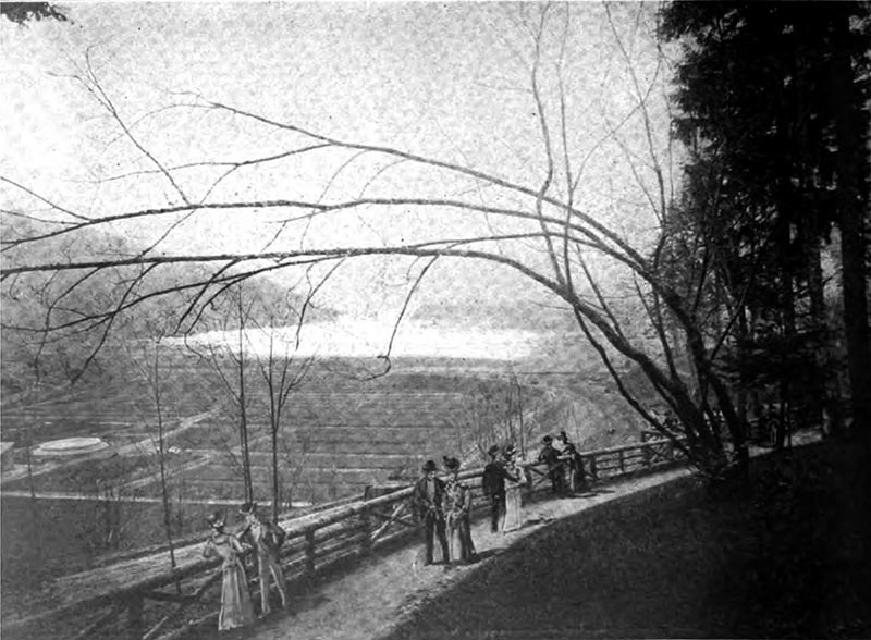
Couples look out over the scenery of Northwest Portland, soon to be the scene of the great Expo . (Image: Laird & Lee Publishers)

And so it was that when the Lewis and Clark Centennial Exposition was held in the summer of 1905, it was on the shores of that lake. Legendary urban designer Frederick L. Olmstead, designer of New York's Central Park, drafted the plan, which included dreamy promenades and palatial buildings along the shore of the lake and on the island-like peninsula in the middle, with a 1,000-foot-long walkway connecting them. Small pleasure boats plied the lake's waters as balloons and airships drifted overhead. It was a gorgeous sight.

Spectators mill around the bandstand at the 1905 Lewis and Clark Exposition, with the lake and the Government Building behind. The largest part of the lake is behind the peninsula the bridge and peninsula the building is on. (Robert A. Reid, Portland)

Who would have believed, strolling along the shoreside promenade at Guild's Lake that summer, that within 20 years it would be utterly gone?

The Guild’s Lake story

A century and a half ago, when the city of Portland was nothing more than a cluster of shacks by the Willamette River, a quiet and sober businessman named Peter Guild (the correct pronunciation rhymed with "smiled") perfected a claim on the lake and surrounding land, and built a public house there.

Visitors stroll along the Esplanade, with the Expo buildings in the background and Guild Lake below . (Image: Robert A. Reid, Portland)

It was a big success. The setting couldn't be beat; the eight-sided log structure was built on that  peninsula, which stuck out into the lake like a tongue. Waterfowl were everywhere, and the fishing was great. It was a sportsman's paradise.

As time went by, Guild and his family sold their land and moved on, and by the turn of the 20th century, it was mostly owned by real-estate speculators who could see that it was in the path of progress.

Then along came the Exposition.

A rented paradise

The lakeside American Inn, as seen from the promenade along Guild's Lake. (Image: Laird & Lee Publishers)

The flinty-eyed businessmen who were planning the Exposition had a firm purpose in doing so: To make money now and promote Portland so they could make more later. They were not about to spend an extra dime on the operation. So when they got started preparing for the event, they didn't buy the land it was on: they leased it.

The official map of the Lewis and Clark Exposition fairgrounds, including Guild Lake. (Union Printing Co.)

So although the millions of visitors who strolled through the Exposition grounds surely thought it would end up as a city park, the property owners knew otherwise. It was in the contract that every building on the fairgrounds had to be completely removed in 1906. Nice as it might be as a city park, the owners of the land had other plans — and, they thought, much more profitable ones.

The bandstand at the Expo after dark, with the lights shining on the water, as seen from across Guild's Lake . (Image: Robert A. Reid, Portland )

They were right. It was a no-brainer. Guild Lake was right on the river, in the middle of what was still the second busiest port on the West Coast, surrounded by railroad lines. As industrial land, its shores were very valuable.

A view across the Expo buildings toward the Willamette River . (Image: Robert A. Reid, publisher, Portland)

So Guild Lake went back to being bare land ... for a time. And people started in thinking about how much more valuable it would be if it were filled in.

[EDITOR'S NOTE: In "reader view" some phone browsers truncate the story here, algorithmically "assuming" that the second column is advertising. (Most browsers do not recognize this page as mobile-device-friendly; it is designed to be browsed on any device without reflowing, by taking advantage of the "double-tap-to-zoom" function.) If the story ends here on your device, you may have to exit "reader view" (sometimes labeled "Make This Page Mobile Friendly Mode") to continue reading. We apologize for the inconvenience.]

(Jump to top of next column)

The front cover of “Glimpses of the Lewis and Clark Exposition,” a souvenir booklet printed for the event by a Chicago publisher, shows a hand-painted overview of Guild’s Lake when the Exposition was under way on its shores in 1905. (Image: Laird & Lee Publishers)


A little later, a crafty businessman from Colorado named Lafe Pence got hold of the place. Pence knew his way around the mining and irrigation laws, and before anyone knew what was going on he'd managed to snake up the water rights to almost every waterway in the area, including all the Portland creeks as well as the Sandy River and many others.

A giant waterslide that plunged swimmers into the lake was a major attraction for both young and old . (Image: Laird & Lee Publishers)

In fact, the city just barely saved Bull Run when Pence tried to snap it up, which would have meant he could have started charging the city for its water.

Now Pence turned his attention, and his aqueous assets, to bear on Guild Lake. His plan was to divert Johnson Creek and Balch Creek into flumes, with which he would blast the steep hillside next to the lake, washing dirt down into it — and, he hoped, filling it up so that he could sell industrial lots there.

The Bridge of Nations, leading from the promenade to the peninsula with the Government Building on it . (Image: Robert A. Reid, Portland)

The plan to move the mountains into the valley turned out not to be a particularly good one. A few years and several hundred thousand dollars later, Pence gave up on the project. (Here's a link to an Offbeat Oregon article about Pence and his scheme.)

But at almost the same time, the Willamette River was being dredged to give it a bigger shipping channel, and to ensure it was navigable all year long; before 1900, some ships couldn't get to Portland's docks in August and September due to low water levels.

Millions of cubic yards of silt and dirt were getting pumped off the floor of the Willamette River, and it all had to go somewhere.

The government buildings as seen across the lake by night . (Image: Laird & Lee Publishers)

That somewhere turned out to be Swan Island — which was enlarged and connected to the shore, so that it was no longer really an island — and Guild Lake.

Over a period of a half-dozen years in the 1910s, the riverbottom was pumped up and poured into the lakebed. At the same time, hundreds of thousands of yards of dirt were being trucked to the lake from construction projects in the hills of Portland, which were being terraced so houses could be built there.

The government building as seen by day. (Image: Robert A. Reid,
Portland )

By the early 1920s, Guild Lake was gone without a trace.

As industrial land, the former lake was fabulous: flat and open, with railroad lines handy to almost every lot and the seaport right there as well. Industrialists rushed to buy the lots, and the Oregonian gushed that Guild's Lake was destined to become the industrial center of Portland.

Another view of the grand stairway . (Image: Laird & Lee Publishers)

And, well, it's certainly become one of them.

Today, Guild's Lake lies beneath cubic acres of fill dirt on the river side of Highway 30, just as it leaves Interstate 405. Northwest Yeon Avenue goes right through the middle of it. So next time you're driving across the Fremont Bridge, take a look northward from the west end; the landscape you're looking at was, in 1905, the beautiful and pastoral lakeside scene that's shown in postcards and memorabilia from the Lewis and Clark Exposition.

Yes, it's valuable industrial land, and helps give Oregonians jobs and income. But it's worth remembering that, well, we traded something for that.

(Sources: Pintarich, Dick. Great and Minor Moments in Oregon History. Portland: New Oregon, 2008; MacCall, E. Kimbark. Merchants, Money and Power. Portland: Georgian Press, 1988)