


you just might ALSO
enjoy ...

Whale explodes: Details at 11.
The highway department guy didn't know how much dynamite to use, and said so on camera. But he still thinks the operation was a success. Check out the story of Florence's famous exploding whale ...

Far-out guru "enlightens" Central Oregon.
What happens when a colony of acolytes of an East Indian guru move in, then try to take over Wasco County? Check out the four-part story of the rise and fall of Rajneeshpuram ...

this oregon youth went on to save half a billion lives...guess who?
A local Willamette Valley teen-ager named Bert Hoover, an orphan sent from Iowa to live with his uncle, went on to save millions of lives and become a singularly ill-starred U.S. president.

oregon's most spectacular shipwreck ever.
The steam schooner J. Marhoffer was almost brand-new when, burning fiercely from stem to stern, it piled onto the rocks near Depoe Bay. It's the remains of this fiery shipwreck that gave Boiler Bay its name ...
the gallant rescue of portland's floating brothel.
Maritime madam Nancy Boggs kept her bordello on a barge floating in the river, until a police raid cut it loose. But the captain and crew of a sternwheeler came to save the day. Here's the story.

take off to the province of oregon, eh?
Few people know how close Oregon came to officially becoming a British possession under the treaty that ended the War of 1812. Only the presence of a handful of scattered, starving survivors from Astor's fur enterprise prevented it. Here's how.
timberline lodge could have been a glass skyscraper
Calling the plan a "profit-making eyesore," a Forest Service manager nixed 1920s plan for a modern steel-and-glass structure with an aerial tramway. You can read about it right here.

pixieland: an edgy, vanished amusement park
Built in the late 1960s as a "fairy-tale history of Oregon," the amusement park lasted just a few years before slipping into receivership. Today, all that's left of this odd and uniquely Oregonian story is a dilapidated guardshack.

Did this tiny, soggy, scary road save Oregon’s public beaches?
Until Highway 101 was built in the 1930s, the beach was Arch Cape’s only road to the outside world — a fact that was Exhibit A in Governor Oswald West’s plan to save the beaches.
EDITOR'S NOTE: A revised, updated and expanded version of this story was published in 2024 and is recommended in preference to this older one. To read it, click here.
By Finn J.D. John — November 28, 2010
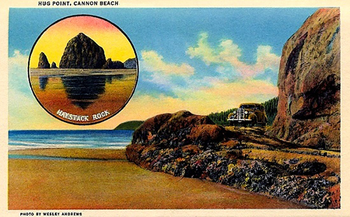
This postcard image from the 1930s shows the Hug Point road when it
was the only access to the outside world for the hamlet of Arch Cape.
(Image: Jeff Jenson, https://home.comcast.net/~bygonebyways)
Downloadable audio file (MP3)
One of the strangest and most important roads in Oregon’s history is flooded almost every day. It has been since it was first built. Its origins are mysterious and for a good half-century the only traffic it’s seen is people on foot.
But a century ago, this roadbed was part of Exhibit A in Governor Oswald West’s bid to save Oregon beaches by declaring them state highways.
The road is a very short one-lane stretch cut and blasted into the rocky headland at Hug Point, just south of Cannon Beach. It’s actually just a small part of the old road from Arch Cape to Cannon Beach — in fact, the road is the beach.
When the beach highway WAS the beach
Drivers today do plenty of griping about the stretch of Highway 101 that covers that part of the coast.
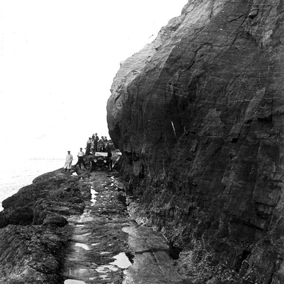
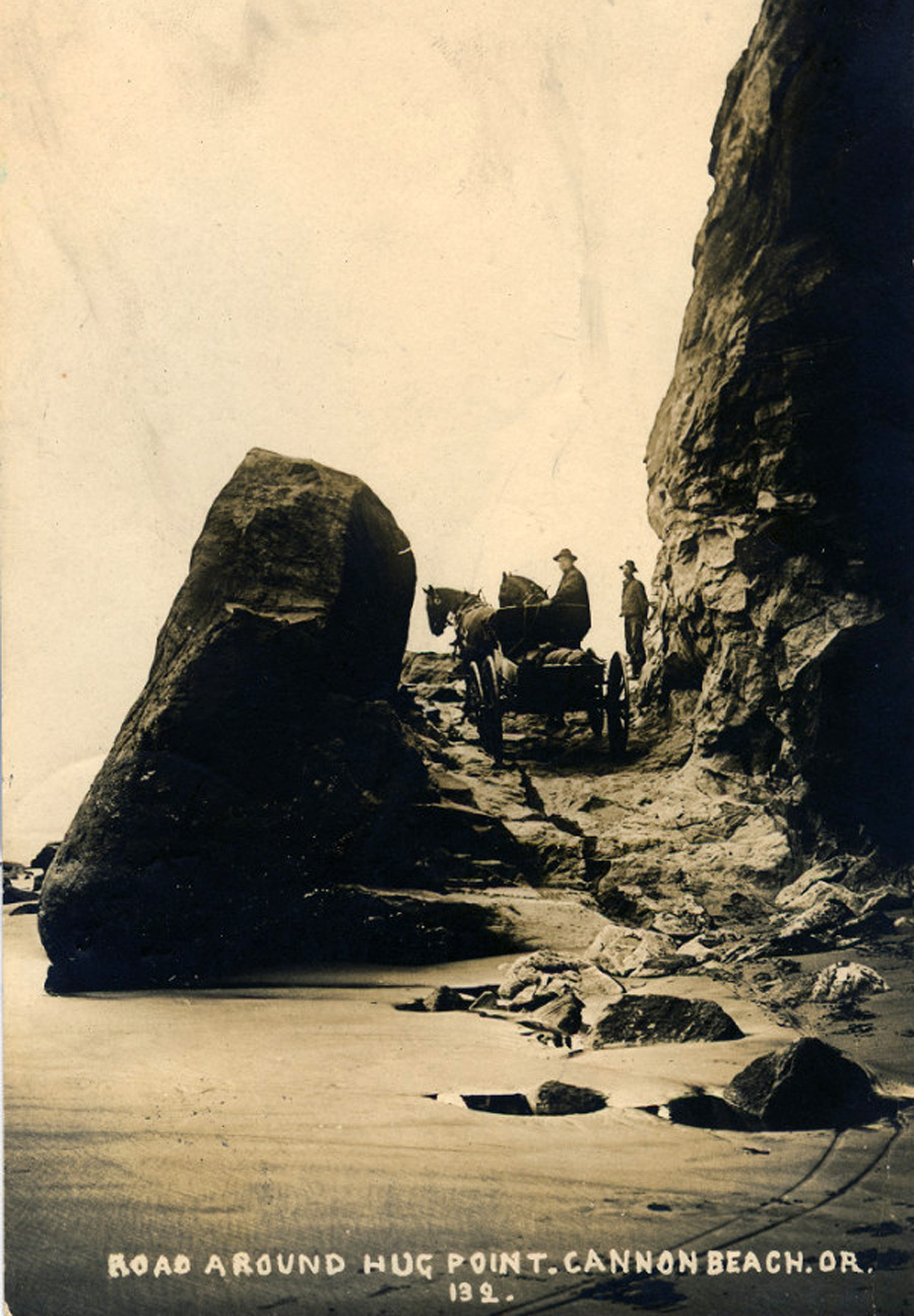
This image, made around 1915, shows a group with a motorcar
traversing the Hug Point Road when it was the tiny settlement of Arch
Cape’s only access to the outside world. (OSU Archives, Gerald W.
Williams collection)
They don’t know how good they’ve had it since 101 was finished in the late 1930s. Before that, travelers driving down the coast had to use the beach. And there was one particular spot everyone dreaded: Hug Point.
Hug Point got its name because travelers wanting to get from Cannon Beach south to Arch Cape had to wait for low tide and hug the point to get past it. It’s a steep, rugged ridge of the Coast Range that thrusts right out into the surf, to its very edge.
It was a regular feature on the stagecoach run up and down the beach. Into the sea the coach would plunge, and around the cape it would go. Nerve-wracking, yes, but any other way around the point would have involved a long inland detour, a big elevation gain and a whole lot of switchbacking and bushwacking.
Problem solved, with dynamite
Hug Point might have been an inconvenience for stagecoaches, but when automobiles started appearing it must have been a real problem. It takes a lot less water to stop a car than a stagecoach, and it’s much easier to get one stuck in beach sand.
So someone — I still haven’t been able to figure out for sure who, or when — someone blasted and chipped a roadbed out of the headland.
How did that road come to be? I’d love to know. Several sources claim it dates to 1920, when a man from Arch Cape bought a brand-new Maxwell motorcar and tried to drive it home. It reportedly got stuck in the surf while driving around the point, and the incoming tide submerged it. The man was so angry he raised subscriptions from his neighbors, bought dynamite and blasted out the roadbed — so the story goes.
The problem is, I have a photo of a horse-and-wagon team negotiating that roadbed that dates from 1910, and Ralph Friedman actually talked to a stagecoach driver who routinely drove the road well before 1920.
So who actually did the blasting and chipping? The Postal Service? The stagecoach line? Local residents? And when? Several hours of diligent scrounging through the catalogue at Oregon State University’s Valley Library have turned up absolutely nothing. Whoever did it clearly didn’t think it important enough to mention. If you know, I’d love to hear from you.
In any case, it worked. Stagecoaches, wagons and now automobiles could finally cross Hug Point at low tide without getting pickled in corrosive saltwater. And cross it they did, regularly; after all, there was no alternative.
Governor's challenge: Stop Legislature from giving away beaches
Meanwhile, the Oregon public was getting increasingly agitated about the beaches. They were being sold off.
This image, which probably dates from the first decade of the
20th century
, shows a team of horses crossing Hug Point Road
(OSU Archives, Gerald W.
Williams collection)
The state legislature was diligently selling them at bargain prices to legislators’ friends and associates, and the spectre of “No Trespassing” signs in the sand loomed.
In response to this (among other issues), voters elected Oswald West as governor. His platform was in no small part centered around a promise to save the beaches. Once in office he knew what he had to do — but how could he do it?
Well, most Oregonians know how he did it — by getting the beaches declared state highways. But what most don’t realize is that West had to get that action approved by a hostile legislature that really wanted to keep playing Santa Claus with beachfront property.
The beach really was a highway
The only reason he was able to do this is because he was right. In many places, the beaches really were highways, and there were no alternative routes.
That fact made all the difference. For 1910s legislators, it was one thing to vote to sell off a soft asset like a recreational area. Voting to unload a state highway on which voters depended for contact with the outside world was another matter.
So West got his bill. And we got our beaches. And, a little over 20 years later, the Arch Cape residents got a real highway — the Roosevelt Military Highway, or Highway 101 — and the Hug Point road fell into disuse.
Today it’s a state park, and at low tide beachgoers can stroll from one end to the other of the only remaining evidence of the road that saved Oregon’s public beaches.
(Sources: Friedman, Ralph. In Search of Western Oregon. Caldwell, Idaho: Caxton, 1978; Sullivan, William L. Hiking Oregon’s History. Eugene, Ore.: Navillus, 2006; www.ohs.org (Oregon Historical Society))