


oregon field guide solves a mystery:

Did they blow
it up?
Some people believe the rocky outcroppings that made the falls were dynamited by the Corps of Engineers before or just after they were flooded. This 2008 episode of Oregon Public Broadcasting's Oregon Field Guide settles the question.
before and after shots:
From the Oregon Historical Society comes this riveting demonstration of the change the dam made in the river. You can compare the same photo of the river taken in 1956 and 1972. It will take you about 45 seconds to check this one out, and you'll be glad you did.
where is this place, anyway?
View Larger Map
You just might ALSO
enjoy ...

Whale explodes: Details at 11.
The highway department guy didn't know how much dynamite to use, and said so on camera. But he still thinks the operation was a success. Check out the story of Florence's famous exploding whale ...
Far-out guru "enlightens" Central Oregon.
What happens when a colony of acolytes of an East Indian guru move in, then try to take over Wasco County? Check out the four-part story of the rise and fall of Rajneeshpuram ...

this oregon youth went on to save half a billion lives...guess who?
A local Willamette Valley teen-ager named Bert Hoover, an orphan sent from Iowa to live with his uncle, went on to save millions of lives and become a singularly ill-starred U.S. president.

oregon's most spectacular shipwreck ever.
The steam schooner J. Marhoffer was almost brand-new when, burning fiercely from stem to stern, it piled onto the rocks near Depoe Bay. It's the remains of this fiery shipwreck that gave Boiler Bay its name ...
the gallant rescue of portland's floating brothel.
Maritime madam Nancy Boggs kept her bordello on a barge floating in the river, until a police raid cut it loose. But the captain and crew of a sternwheeler came to save the day. Here's the story.

take off to the province of oregon, eh?
Few people know how close Oregon came to officially becoming a British possession under the treaty that ended the War of 1812. Only the presence of a handful of scattered, starving survivors from Astor's fur enterprise prevented it. Here's how.
timberline lodge could have been a glass skyscraper
Calling the plan a "profit-making eyesore," a Forest Service manager nixed 1920s plan for a modern steel-and-glass structure with an aerial tramway. You can read about it right here.

pixieland: an edgy, vanished amusement park
Built in the late 1960s as a "fairy-tale history of Oregon," the amusement park lasted just a few years before slipping into receivership. Today, all that's left of this odd and uniquely Oregonian story is a dilapidated guardshack.

Columbia River was a wild, frothy, dangerous place once
It was known for spectacular scenery, enormous waterfalls and whitewater stretches, and phenomenal fishing; we've traded that for a placid, lake-like waterway and cheap hydroelectric power.
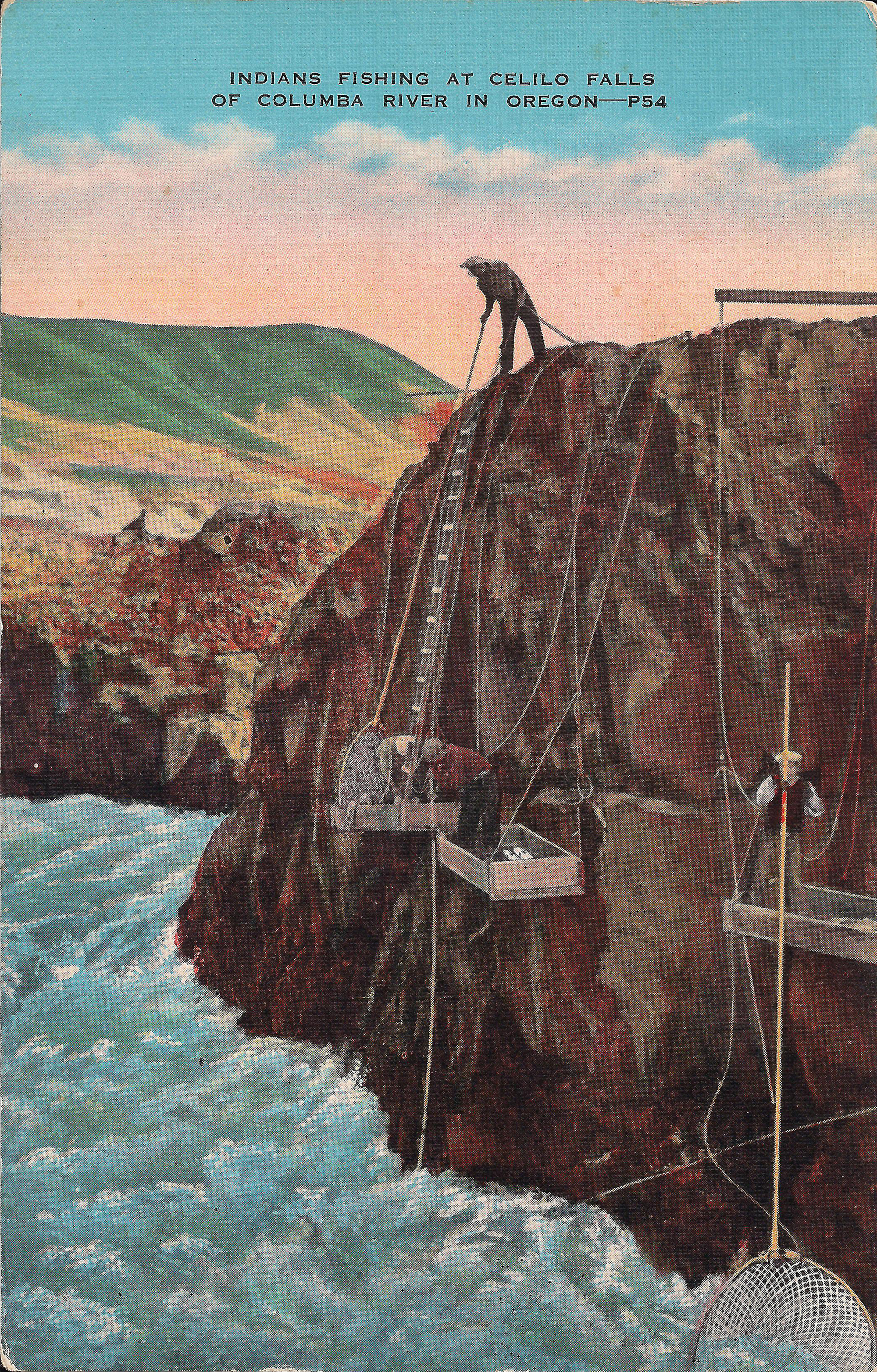
This postcard image, dating back to the 1920s, shows some of the
techniques used by Native Americans fishing with dipnets at Celilo Falls.
By Finn J.D. John — September 6, 2010
Downloadable audio file (MP3)
Downloadable audio file (MP3)
If you first encountered the Columbia River Gorge sometime after 1957, chances are you think of the river that runs through it as being like a big, long lake.
And that’s more or less what it is today. It impresses with its bigness, but it’s no Mississippi. In places its current is swift, but it’s nothing you can’t make good progress against in a canoe. Other than the scenery rising from each bank, it doesn’t appear particularly remarkable. Just a big river, that’s all.
Wilder in its youth
But the Columbia River wasn’t always so tame. There was a time when all the water in this, America’s fourth-largest river, cascaded through stony slits and roared through a 40-foot rocky gap before it reached the quieter stretch from Portland to Astoria. It was wild, turbulent and as dangerous to boaters as Niagara Falls.
Salmon swarmed upstream every year, dashing themselves against the rocks in a struggle to get upstream. Native Americans stood on platforms that hung out over the rocks — platforms that looked rickety and dangerous, but did not flex or move so much as an inch under their weight — and scooped the big fish out of the water with dipnets. They had been doing this for time out of mind.
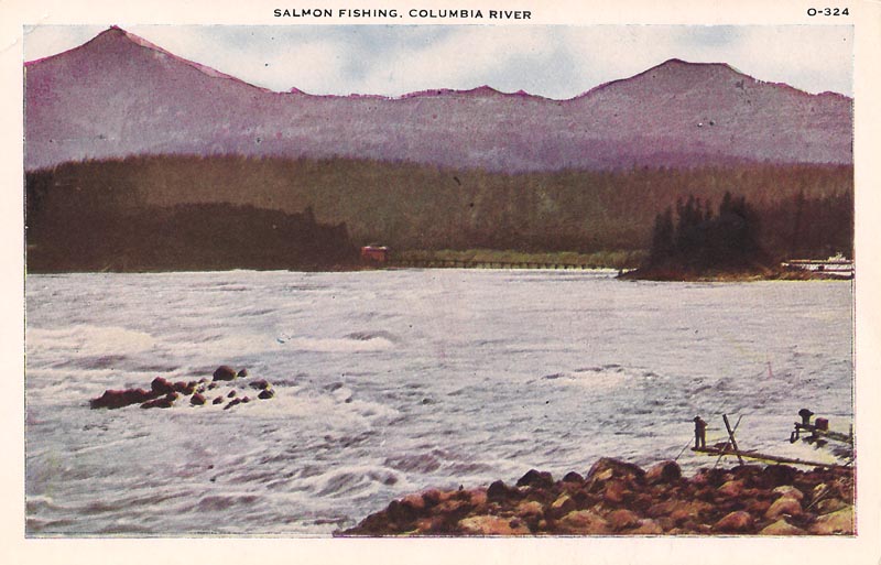
This picture postcard from the 1930s shows people, apparently Native
Americans, using a fishing platform to get salmon out of the Columbia.
This scene might be at the Cascades near Cascade locks, or possibly
just upstream from Celilo Falls.
That was the river Lewis and Clark encountered in 1806. And the central point of the river was Celilo Falls, just east of what’s now The Dalles.
Celilo Falls was the epicenter of the oldest continuously inhabited human settlement in North America. Every year, millions of migrating salmon made the living easy; although dipnet fishing was fraught with hazards, starvation was not one of them.
Domesticating the wild river
The change in the river started in 1937, when Bonneville Dam was created in part to flood the torrential rapids by the town of Cascade Locks.
But the watershed year was 1957 – the year Celilo Falls disappeared beneath the surface of what is today officially called Celilo Lake, a reservoir backed up behind The Dalles Dam.
The decision to flood the falls was surprisingly uncontroversial by modern standards. Mostly it came down to the Native American tribes that lived and fished at the falls fighting to “stop progress.”
The tribes had international law on their side — a treaty that let them fish at the falls — but it wasn’t enough. Each tribe member got a lump-sum cash buyout roughly equivalent to the value of a new Cadillac, and they watched sadly as their falls disappeared under 20 feet of still water.
Why was the government so keen to do this?
Most powerful river in America
Well, regardless of appearances, the Columbia really is an extraordinary river. A full one-third of North America’s hydroelectric power-generating potential is on the main stem Columbia River. It has an unusual combination of enormous volume — five times that of the Colorado River; rapid elevation drop; and steep banks so that the impoundments behind dams don’t spread out as far.
Plus, it’s relatively wild and unsettled, meaning fewer people have to be paid off through condemnation proceedings when their property is flooded.
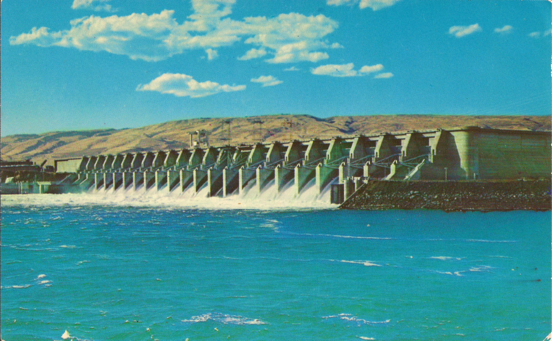
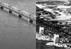
This postcard image shows The Dalles Dam, which flooded Celilo Falls
when it was built in 1957. [Larger image: 1800 x 1112 px]
Columbia helped win a war
Hydroelectric projects at Grand Coulee and Bonneville created enough electricity during World War II to have a noticeable impact on America’s war effort.
After the war, the country’s standard of living was rising fast, and it was all powered by electricity — generated either expensively at coal-fired plants, or cheaply by dams on America’s big rivers.
Once Celilo was under water and The Dalles Dam started generating power, it put out an enormous amount — although comparison with the rate of electric-power consumption in the U.S. makes it look less impressive than it is. According to the U.S. Army Corps of Engineers, the dam’s powerhouse generates enough to satisfy the power needs of two cities the size of Portland – whose population figure is just over 575,000. So the dam produces roughly three-eighths of one percent of the electricity needs of the country.
But have we lost something more?
Of course, that’s power that would have to be generated in other ways — probably by burning coal — if there were no dam at The Dalles.
But Celilo Falls was unique. There was nothing like it on the face of the earth, and now it’s gone.
Was it a good trade? It’s at least a question worth considering.
(Sources: Friedman, Ralph. In Search of Western Oregon. Caldwell, Idaho: Caxton, 1990; Gulick, Bill. Roadside History of Oregon. Missoula, Mont: Mountain Press, 1991.; Patton, Vince. “Celilo Remembered,” Oregon Field Guide. Portland: Oregon Public Broadcasting, 2008; Wilkinson, Charles. “Celilo Falls at the Center of Western History,” Oregon Historical Quarterly, v. 108, n. 4, winter 2007.)
TAGS: #HoodRiverCounty #CascadeLocks #CeliloVillage #TheDalles #Indian #Marine #LostCities #ColumbiaRiver #Salmon #Dipnets #BonnevilleDam #CeliloLake #Progress #RalphFriedman #BillGulick #VincePatton #CharlesWilkinson
-30-